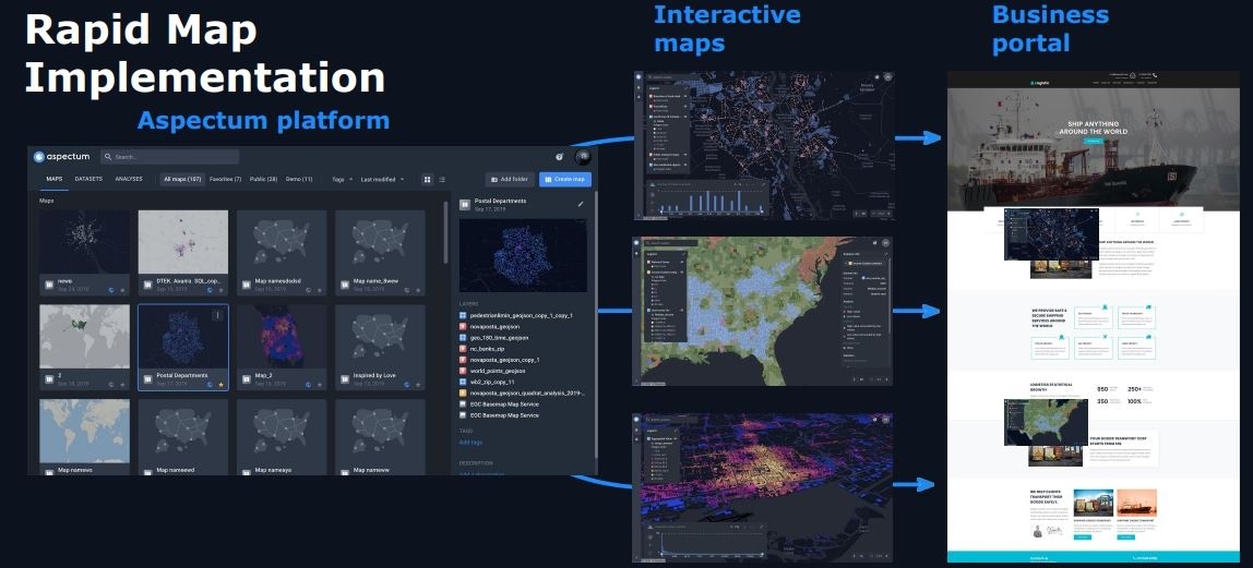
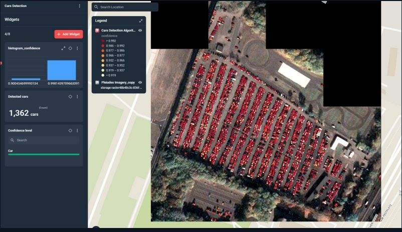
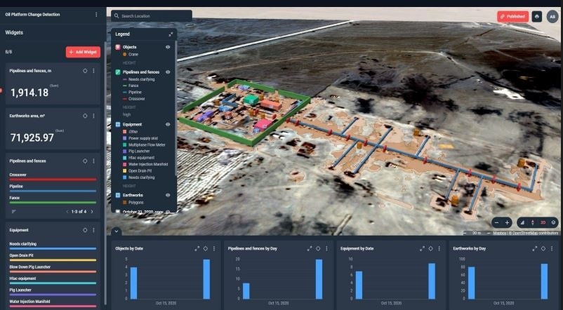
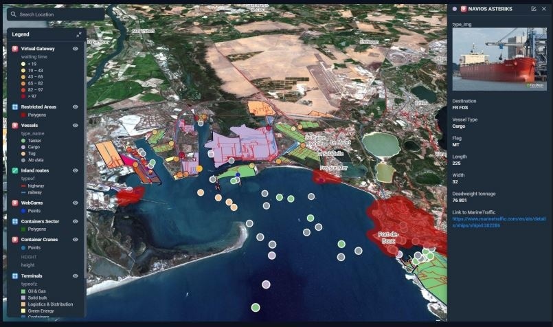
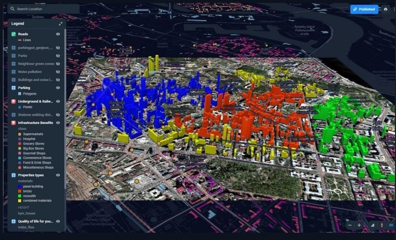
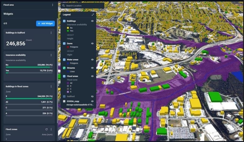
C1 SMART™ Satellite Monitoring & Geospatial Analytics provides real-time area and infrastructure monitoring across urban, industrial, and environmental sites throughout Dubai, Abu Dhabi, Sharjah, Ajman, Umm Al Quwain, Ras Al Khaimah, Fujairah, Muscat, Sohar, Salalah, Nizwa, Sur, Doha, Al Wakrah, Al Khor, Riyadh, Jeddah, Dammam, Khobar, Mecca, Medina, Manama, Riffa, Muharraq, Kuwait City, Hawally, Salmiya, Fahaheel, and other Middle East cities. Using high-resolution satellite and drone imagery, the system detects environmental and industrial changes, monitors infrastructure development, tracks fleet and vehicles, and identifies potential risks. Multi-layer geospatial visualization, AI-driven analysis, and digital twin modeling ensure proactive decision-making, enhanced operational efficiency, and actionable insights for disaster management, environmental safety, and smart city planning.
Monitor any area of interest, detect environmental to industrial changes, analyze safety, and prevent pollution using satellite and drone imagery.
Operational across UAE, Oman, Qatar, Saudi Arabia, Bahrain, Kuwait, and India. Provides change detection, environmental safety assessment, and disaster risk prediction for proactive decision-making.
Quick implementation of maps, infrastructure change detection, and creating digital twins with multi-layer visualization and analytical widgets.
Analyze satellite and drone imagery, track construction of large infrastructure, visualize multiple layers, and sort historical data for actionable insights.
Detect cars and trucks in urban and rural areas using satellite and drone imagery with up to 96% confidence for fleet and parking management.
Create interactive digital mapping dashboards, visualize multi-layer infrastructure, and track fleets in real-time across cities and industrial zones.
Monitor oil platforms and industrial infrastructure development with weekly change detection, object measurements, and environmental safety analysis.
Predict oil & gas consumption based on active platform status, assess environmental impact, and ensure safe operations across Middle East regions.
Multi-layer visualization of port infrastructure, vessel tracking, cargo flow analysis, and capacity assessment using satellite and drone imagery.
3D modeling of terminals, real-time monitoring via API integration, and analysis of supply chains to optimize port operations and transportation hubs.
Visualize urban and environmental factors, calculate walking distances, categorize buildings, and assess quality of life using geospatial data.
3D building visualization, multi-layer mapping, and spatial analytics enable city planners and authorities to optimize urban infrastructure and public services.
Analyze flood density, property risk, and historical data to prepare for natural disasters and ensure environmental safety.
Provide risk assessments for retail and real estate, environmental and climate change studies, and predictive insights to minimize losses and improve emergency response.
Activate high-resolution satellite imaging, aerial drones, and IoT sensors across strategic sites for continuous geospatial monitoring.
Connect all satellite and drone data streams to centralized C1 SMART hubs for unified geospatial and infrastructure intelligence.
Use AI and machine learning to detect environmental changes, track infrastructure development, monitor industrial sites, and predict risks in real time.
Get instant notifications on anomalies, construction changes, environmental risks, or unauthorized activity directly on dashboards and mobile devices.
Maintain continuous oversight of urban, industrial, environmental, and critical infrastructure with satellite imagery, drone feeds, and digital twin visualizations.